
OUR SERVICES
REAL
ESTATE
COMMERCIAL &
RESIDENTIAL


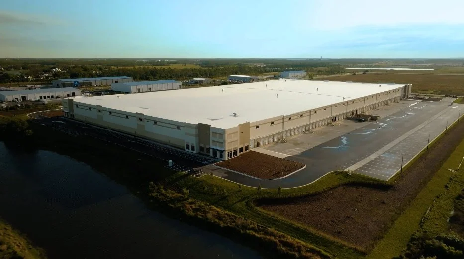


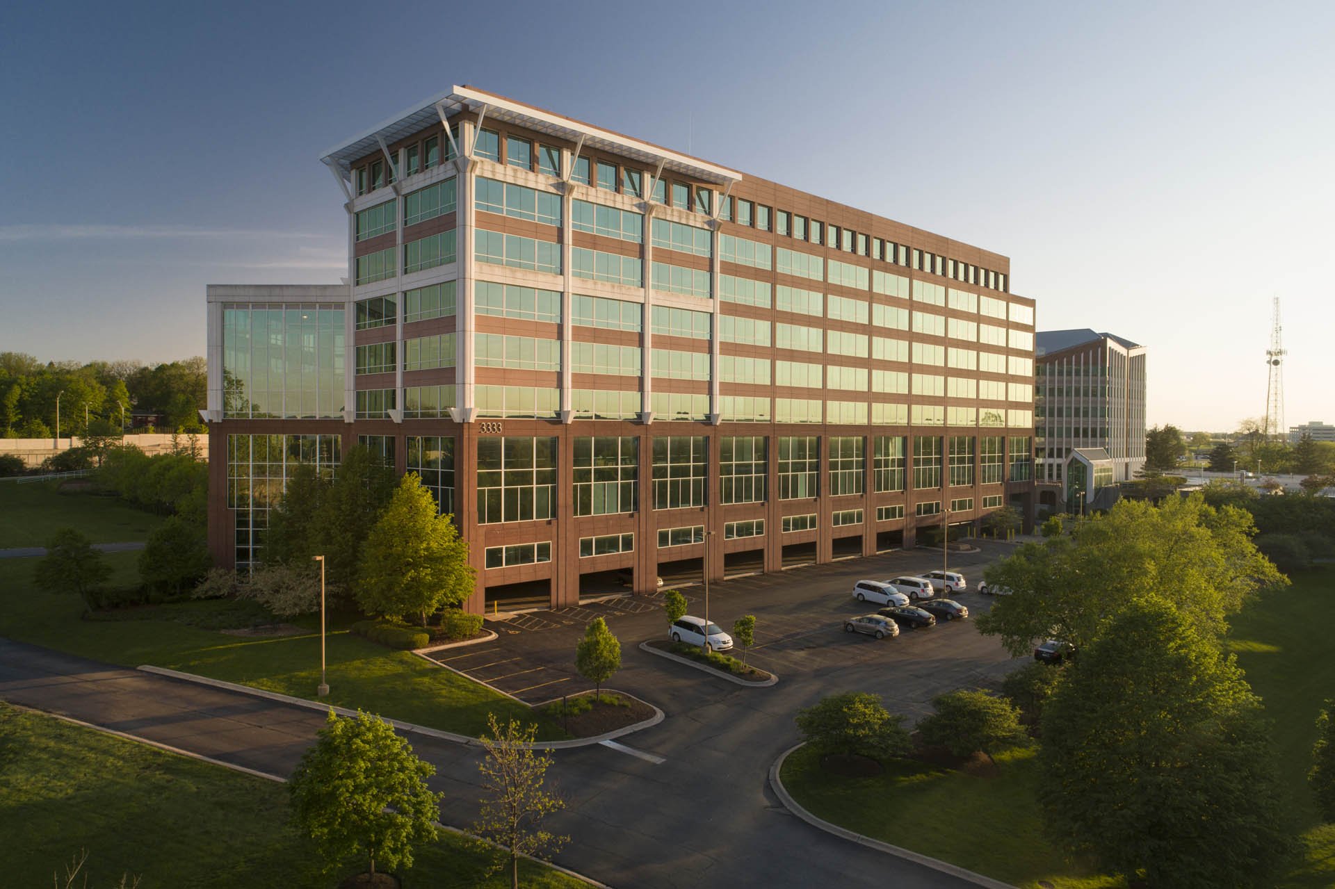

Professional drone services have revolutionized the real estate industry, providing unparalleled aerial perspectives that enhance both property listings and marketing strategies alike. RECON offers high-resolution ground-based and aerial photography and videography that captures stunning, wide-angle views of properties, highlighting their unique features and surrounding landscapes. Aerial shots not only showcase the property in its best light but also give potential buyers a comprehensive understanding of the layout and neighborhood, making listings more engaging and informative.
In addition to standard aerial imaging, our team also provides advanced drone services for real estate, such as virtual tours and interior fly-throughs. This immersive experience helps buyers visualize themselves in the space, making it easier to explore every corner of the property without physically being there. Virtual tours, paired with high-quality drone footage, offer a seamless way to present the property’s interior and exterior, providing a cohesive view that traditional photos alone could never achieve.
Our professional drone services offer real estate clients cutting-edge solutions to elevate property marketing through high-resolution aerial photography, cinematic videography, and eye-catching virtual tours. By providing a truly immersive experience, we enhance property listings and engage potential buyers more effectively. Ultimately, our drone services can help real estate professionals showcase properties in their best light, drive interest, and achieve their sales objectives with greater impact than ever before!
Some of the most popular services we provide for Real Estate professionals include:
Property & Land Aerial Photography & Videography
Home Exterior Aerial Photography & Videography
Home Interior Drone Fly-Throughs
Post-Production Editing & Color-Grading
Social Media Content Creation
High-Resolution Aerial Photos & Videos for Print or Digital Marketing & Promotions
Highlight Reels, Listing Showcases, Walkthroughs, etc.
Custom Logo & Branding
Horizontal or Vertical content options
CONSTRUCTION
& JOBSITES
RESIDENTIAL &
COMMERCIAL


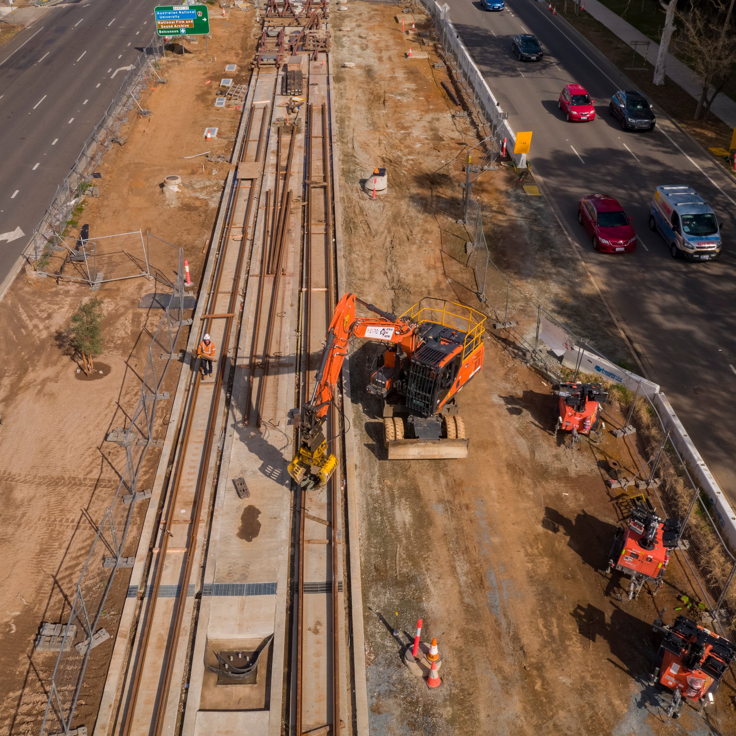

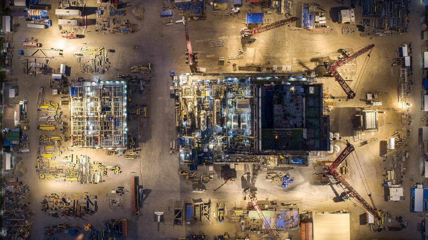


Professional drone services have become indispensable for the construction and building industries, offering a range of solutions that enhance project management and oversight. The team at RECON provides high-resolution aerial imagery and videography to capture detailed views of construction sites from above. These visuals are invaluable for monitoring progress, identifying potential issues, and ensuring that work aligns with architectural plans. By providing clear, comprehensive imagery, we can help construction managers and stakeholders stay informed and make timely decisions that keep projects on track.
Our professional drone services specialize in aerial mapping and documenting job site progression, providing critical insights for construction and project management. By leveraging high-resolution aerial imagery, we capture comprehensive and detailed snapshots of job sites at various stages of development. This ongoing documentation allows project managers and stakeholders to track progress accurately, compare current conditions with initial plans, and ensure that work is progressing as scheduled. The visual records we provide are invaluable for identifying discrepancies, validating project milestones, and communicating updates with clarity and precision.
We also offer advanced aerial mapping services that produce detailed images of job sites. Our drones capture precise geospatial data, enabling the creation of accurate, scalable maps that facilitate in-depth analysis and planning. These maps are crucial for understanding site conditions, managing resources, and making informed decisions about project modifications. They also serve as a valuable reference for verifying measurements and planning future phases of construction, ultimately enhancing efficiency and reducing the risk of errors.
Our comprehensive approach to capturing construction visuals, aerial mapping, and job site documentation supports smoother project execution and helps achieve timely and successful project outcomes.
Some of the most popular services we offer to the Construction industry include:
Jobsite Aerial Photography & Videography
Work Progression Timelapses & Recurring Photo & Video Documentation of Worksites
Jobsite Drone Fly-Throughs (Indoor or Outdoor)
Post-Production Editing & Color-Grading
Social Media & Online Marketing Content Creation
High-Resolution Aerial Photography & Videography for Print or Digital Marketing
Jobsite Highlight Reels, Fly-Through Videos, Timelapses, WorkFlow Visualizations
Custom Logo & Branding
Horizontal or Vertical content options
ONLINE
MARKETING
& SOCIAL
MEDIA


The team at RECON offers a comprehensive suite of online marketing services designed to elevate your brand's presence in the digital world. By utilizing cutting-edge drone technology, we provide stunning aerial footage and photography that captures the unique angles and perspectives of your business or brand. These high-quality visuals are perfect for enhancing your website, optimizing your online advertising campaigns, and improving your overall digital footprint. Our team of professionals will ensure that your content is always reaching the right audience, ultimately driving traffic and engagement to your platforms and business.
In addition to online marketing, RECON specializes in creating content specifically designed for social media growth, helping you build a robust and active online community. By curating visually striking drone content tailored for social media platforms like Instagram, Facebook, TikTok, X, and others, we can help give a boost to your social media presence and engagement rates. Our team will work hard to ensure your social media channels remain vibrant and engaging, attracting more followers and potential customers.
Content creation is at the heart of our services, offering bespoke solutions to meet your unique marketing needs. Our team of creative professionals will work closely with you to understand your brand's voice and vision, crafting compelling stories through high-resolution drone videos and photos. From promotional videos and virtual tours to behind-the-scenes footage and product showcases, our company’s content creation services deliver captivating visual narratives that are sure to resonate with your audience. By integrating this dynamic content into your marketing strategy, you can significantly enhance your brand's appeal and marketability, truly setting yourself apart from the competition.
Some of the services specific to Marketing & Social Media that we offer include:
Content Capture for Business & Brand Promotion
(Storytelling, Location Openings, Online Advertising)Immersive Marketing
(Fly-Throughs, Virtual Tours, 360° Photos & Videos)Location-Based Marketing
(Local Highlights, Building Shots, Destination Footage)Product Showcases, Cinematic Ads, Highlight Reels
Advanced Post-Production Content Editing, Color-Grading & Sound Design
SURVEYS
MAPPING
& INSPECTIONS


RECON also offers advanced mapping services that utilize the latest in drone technology to provide accurate and detailed geospatial data. These services include high-resolution aerial mapping, 3D terrain modeling, and orthomosaic map creation, which are essential for urban planning, construction projects, and agricultural management. Our drones capture images with precision, allowing for the creation of detailed maps that can be used for analysis and decision-making. With the ability to cover large areas quickly and safely, our mapping services provide cost-effective and timely solutions for clients in various industries.
In addition to mapping, the team at RECON offers specialized surveying services that enhance accuracy and efficiency in data collection. These services include topographic surveys, volumetric calculations, and land surveys, all conducted using state-of-the-art drone equipment. The high-quality imagery and data collected by the drones allow for precise measurements and detailed analyses, reducing the need for traditional ground surveys. This not only speeds up the surveying process but also minimizes the risk and cost associated with manual surveying methods, making it an ideal solution for engineers, architects, and project managers.
Inspection services offered by RECON are designed to provide safe, efficient, and detailed assessments of structures and sites. These services include inspections of bridges, buildings, wind turbines, power lines, and other critical infrastructure. Drones can access hard-to-reach areas and capture high-resolution images and video, allowing for thorough inspections without the need for scaffolding or aerial lifts. Our inspection services help identify potential issues early, reduce downtime, and improve safety by minimizing the need for manual inspections. This makes it an invaluable service for maintenance teams and safety inspectors across various industries.
Some of the most popular Surveying & Inspection services that we offer include:
Structural Inspections for Roofing, Buildings, Towers, Bridges, Railways, etc.
Infrastructure & Energy System Inspections for Power Lines & Utilities, Solar Panels, Wind Turbines, Pipelines, etc.
Aerial Surveys for Land & Properties
Aerial Surveys for Construction Sites & Buildings
High-Resolution Aerial Mapping & 3D Imaging
Safety Reports & Data Capture
EVENT
PHOTOGRAPHY
VIDEOGRAPHY
& FILMMAKING


RECON offers exceptional event photography and videography services that capture memorable moments from unique angles. With state-of-the-art drones equipped with high-resolution, stabilized cameras, RECON provides stunning aerial footage and images for weddings, corporate events, concerts, sporting events, and more! Our drones can cover large areas and fly at various altitudes, ensuring that every important moment is captured with precision and creativity. Our team of experienced operators works closely with clients to understand their vision, delivering customized and dynamic content that enhances the overall experience of any event.
In addition to event coverage, RECON specializes in filmmaking services that bring a new perspective to storytelling. By incorporating aerial shots and smooth camera movements, our company can help you add a cinematic touch to films, documentaries, commercials, and music videos. Our expertise in drone technology allows for the creation of dramatic scenes and visual narratives that captivate audiences. RECON's filmmaking services include pre-production planning, on-site filming, and post-production editing, ensuring a seamless and professional final product. Whether it's a scenic landscape shot or an intense action sequence, our drones provide the flexibility and quality needed to meet the demands of modern filmmaking.
Our team’s dedication to quality and innovation in event photography, videography, and filmmaking makes RECON a standout leader in the industry. We utilize advanced drone technology to offer services that are not only visually stunning but also safe and reliable. With a focus on client satisfaction, our team ensures that every project is executed to the highest standards, delivering content that exceeds expectations. From capturing the emotion of live events to creating visually engaging films, RECON’s professional drone services provide unmatched value and creativity, officially marking us as the go-to choice for aerial photography and videography.
Some of our most popular Event Capture & Filmmaking services include:
High-Resolution Aerial Photos & Videos for Weddings, Concerts, Festivals, Corporate Events, Sports Competitions, Car Shows, etc.
Drone Fly-Throughs & Fly-Overs
(Immersive Flights, Crowd Surfing, Venue Tours)Live Streaming for Social Media, YouTube & Other Media-Sharing Platforms
Aerial Cinematography
(Commercials & Ads, Music Videos, Movies & Documentaries)Aerial Motion-Tracking & Follow Shots
Pre-Production Planning & Storyboarding
Post-Production Editing, Color-Grading & Sound Design
